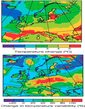
Simulated change in average summer temperature (upper panel) and in interannual variability (lower paned) from the period 1961-1990 to the period 2071-2100.
Project MOSATCLIM comprises a multidisciplinary fundamental research in the field of: Environment, Protection and ecological reconstruction of critical zones and conservation of protected areas, for establishment of data basis and georeferenced methods, of mathematical models and of decisional cycle infrastructure aiming at conservation, rebuilding and sustainable development of biological and ecological diversity components as well as natural and technological hazards/risk assessment research and impact studies in frame of PNCDI2 Program.
Project is aiming at: developing interlinked monitoring and verified predictive and modeling tools for assessment of local, regional and global climatic changes feed-backs on landuse/landcover as well as of the impact of climatic changes on urban, forestry, agricultural, hydrologic, marine and deltaic ecosystems over Romanian territory. Based on biogeophysical parameters extracted from time-series multispectral, multiresolution and multitemporal satellite remote sensing data (Landsat MSS, TM, ETM, NOAA AVHRR, MODIS, SAR ERS, IKONOS and QuickBird), its integration as input data for spectral, statistic and physical/climatic developed models ,project will provide a comprehensive spatio-temporal evaluation framework of climatic changes feedbacks action on different terrestrial ecosystems, by the identifying of the major regime shifts during the last 30 years, to assess ecosystem current state and trends during next 50 years due to changes in climate and anthropogenic forcings.
The innovative character of project is reflected in the close merging of new geospatial technologies with mathematics and natural sciences for impact analysis.
Ecosystems test areas in Romania, will be approached as a coupled climatic/ecological/socio-economic entity, with links and feedbacks to the world climatic/resources changes.